reveal new axeheads. See the English Heritage pdf research report.
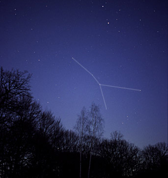
My comment is: "If you can not recognize Ursa Major, the Big Dipper, the Drinking Gourd, when it is patently obvious, then who can help you?"
Here are the axehead positions found on Sarsen 5 by 3D laser scanning (English Heritage) together with my obvious interpretation, where I use for comparison an image from the astronomy software program Starry Night Pro to which image I have added text and block or color emphasis of some elements:
STONEHENGE AXEHEADS on SARSEN 5
as URSA MAJOR (the Big Dipper) and URSA MINOR
(The positions of axeheads are according to English Heritage,
but English Heritage has NOTHING to do with my postings,
and I have made my own images to avoid copyright wrangles,
although use of the axehead positions should be "fair use" in research)
although use of the axehead positions should be "fair use" in research)

Nothing could be clearer than that eight axeheads on the front side of Sarsen 5 at Stonehenge represent the stars of the Big Dipper, i.e. Ursa Major, plus as the largest axe above the others, Ursa Minor, which in the era of Stonehenge construction and use represented the North Celestial Pole --- indeed, even today, the star Polaris at the bottom of the "axe handle" of Ursa Minor, an axe, is the North Pole Star.
What has been written about those axeheads by archaeologists and in the media up to now is ludicrous. I have nothing against pots, but they do not explain Stonehenge, and somehow archaeology should finally realize that. Stonehenge is ASTRONOMY and that is what you should be looking for.
In any case, the reason I found these new axehead laser scans is that I was latching on to my previous postings about ancient seafaring, so I was interested in looking at the recently revealed laser-scanning discovery of more Mediterranean-like two-headed "double axe" Stonehenge axeheads carved on the sarsens and trilithons, as reported at the following websites and blogs:
- English Heritage, Stonehenge -New Evidence for its Solstitial Function and Approach Research Report Series no. 32-2012, Stonehenge Laser Scan: Archaeological Analysis Report, English Heritage Project 6457, Marcus Abbot and Hugo Anderson-Whymark, with contributions from Dave Aspden, Anna Badcock, Tudur Davies, Mags Felter, Rob Ixer, Mike Parker Pearson and Colin Richards -- this is the .pdf of the resarch report where there are images published of the axehead positions
- Dienekes' Anthropology Blog at 3D laser scan of Stonehenge reveals axehead graffiti
- David Keys at the Independent in Stonehenge was a huge prehistoric art gallery: A detailed laser-scan survey of the entire monument has discovered 72 previously unknown Early Bronze Age carvings chipped into five of the giant stones
- Debra Black of The Star in Bronze Age axe heads reveal secrets behind Stonehenge
- Maev Kennedy of the Guardian in Stonehenge up close: digital laser scan reveals secrets of the past
- Archaeological News in Revealed: Early Bronze Age carvings suggest Stonehenge was a huge prehistoric art gallery
"The Stonehenge Sarsens 3, 4, 5, 6, and 7 represent Ursa Major, Leo and Leo Minor, Corvus, Virgo and Coma Berenices, and Boötes."At that time, in fact, I also specifically wrote that Stonehenge Sarsen 4 shows the stars of LEO MAJOR and LEO MINOR. Here was the image I used in my book Stars Stones and Scholars:

More laser-scanned axeheads have been discovered on Sarsen 4, and I show them all together below with Leo Major and Leo Minor, as follows, where the stars of Leo Major and Leo Minor are drawn as the ancients viewed them, with the large lion below and the small lion above:
STONEHENGE SARSEN 4
AXEHEADS PREVIOUSLY KNOWN AND NEWLY DISCOVERED
DECIPHERED (AGAIN) AS STARS OF THE CONSTELLATION LEO
DECIPHERED (AGAIN) AS STARS OF THE CONSTELLATION LEO
(positions of the axeheads according to English Heritage)

To the right of Leo we have the stars of Cancer, a weak group of stars, usually marked by just four or five stars as follows (photograph from the Wikimedia Commons, CancerCC.jpg: author - Till Credner, derivative work - Bedwyr (talk)
SARSEN 3 shows 3 axeheads as stars for the stars of CANCER
(positions of the axeheads according to English Heritage):

In my book Stars Stones and Scholars, page 125 shows the cupmarks on Trilithons 53 and 54, which I there said represent the back stars of Scorpio, where the "stinger is", based on cupmarks in the stone:

Modern man is today unable to see the simplest things and people with no creative art talent think to be able to judge ancient sculpture and carving. Archaeologists or commentators who emote that round cupmarks or carved figures on the megaliths of Stonehenge or elsewhere are "natural irregularities" are more than wrong. They continue -- for reasons known only to them -- to broadcast an uninformed opinion on their part for which there is no basis in the probative evidence. There is nothing out there that even remotely proves that such completely round cupmarks are "naturally" made in stone. Nonsense. Funny thing, cupmarks are frequent on megaliths and on specific cupmarked rock art, but try finding such perfectly round cupmarks on large rocks elsewhere. The same is true for figures on megaliths.
In any case, laser-scanning has also found new axeheads and a dagger ("the sting" of the Scorpion, as it were) on Trilithon 53 (actually it is "Stone 53" which is a trilithon). Not only do those axeheads show the stars of Scorpio and Sagittarius, but they show all the stars of Scorpio, including those at the front, and not just those at the back:

In trying to figure out what the strange curved double-U signs left and right were as stars, the fact that they mark areas of the sky where there are no stars indicated they had a different function. Well, the solution is as obvious as it is not, unless you think of "the Archer" and the "bow and arrow". Those double-U signs then arguably both mark the FINGERS of the HANDS on the bow, one hand at the front, holding the bow at the normal mid-position and the hand at the back, pulling back the string for the arrow, which must be symbolized by the stinger "SHAULA", a term having "shoot" at its root. It is as ingenious as it is simple.


